Map. Back to US36, east to I-71, south across Columbus to I-270, east to US23, south to Chillicothe, US35 south to OH34, south to I-64, east to I-77, south to I-81 at Wytheville, VA.
Beware I-77 in West Virginia! It is Interstate, but it is also the WV Turnpike, a toll road, and it is among the worst roads we have been on the entire trip! It is a concrete highway and every expansion joint is a bump. Even the repairs are being made in concrete and every repair is a bump. And, I remind you, you have to pay extra for using this insult of a highway.
That said, the scenery was more pleasing today, even with the all day overcast. The mountain forests are beginning to show their Fall colors, mostly as a blush, but some almost as a pastel painting, and a few a blaze of glory! And there was even one ridge that treated us to a long view across the tops of the neighboring mountains as we crested it. Beautiful.
We could have driven all the way home tonight, but since it takes a couple of hours to unload the moho after we get there we decided to delay arriving until tomorrow.
It occurred to me that our dinner tonight (last of the trip, darn it) was appropriate. Hot dogs and beans -- and tater salad. Our food budget tapped out? Not really, here we are in Wytheville, VA, eating hot dogs that were really handmade bratwurst from Restvedt & Son Meat Market, of Ennis, MT, near Yellowstone NP. Our favorite brats from our favorite meat market near one of our favorite places in the world. The beans and tater salad were Amish Baked Beans and Amish Potato Salad which MMG bought at the Meijer's in Columbus, OH. They both were different, but really good. The beans were both BBQ hot and sweet and the tater salad was like a combination mayonnaise and mustard tater salad, with a sweet kicker. YUM!
That's about it for the trip and the blog. Will try to do a recap in the next couple of days.
It's been fun -- both the trip and doing the blog. Hope you all have enjoyed at as much as we have!
Love to all.
MMG and DDG
Tuesday, October 6, 2009
Monday, October 5, 2009
October 5, 2009 Decatur, IN to Delaware, OH
The Map: US33 southeast from Decatur, IN, to Marysville, OH, US36 through Delaware, OH, to a left on Lackey Old State Road, 3 miles to Cross Creek Camping Resort. About 135 miles.
After parking the camper, we drove around northern Columbus checking out our old haunts in Worthington, Dublin and the Sawmill areas. Even found our old rental house after 20 years!
 5763 Maplebrook Lane
Some of the maple trees are beginning to shown blushes of their Fall reds and yellows, so that was nice.
Tomorrow, we turn south to get on toward home so we can start getting the lower level of the house put back together and get some needed repairs and maintenance on the moho.
More tomorrow.
Our love to you all.
MMG and DDG
After parking the camper, we drove around northern Columbus checking out our old haunts in Worthington, Dublin and the Sawmill areas. Even found our old rental house after 20 years!
 5763 Maplebrook Lane
That was the high spot of the day. The rest was the 4 hour ride across the farmlands of Ohio, admiring the fields and fields of soybeans, with an occasional cornfield thrown in for good measure. In truth, MMG's high spot was the chance to shop in a Meijer's, kind of an upscale WalMart with a wider variety of merchandise. Kind of liked it myself.
Some of the maple trees are beginning to shown blushes of their Fall reds and yellows, so that was nice.
Tomorrow, we turn south to get on toward home so we can start getting the lower level of the house put back together and get some needed repairs and maintenance on the moho.
More tomorrow.
Our love to you all.
MMG and DDG
Sunday, October 4, 2009
October 4, 2009 Springfield, IL to Decatur, IN
The map! East from Springfield on I-72 to Champaign-Urbana, then I-74 east to Indianapolis, IN, I-435 around Indianapolis to I-69 northeast to exit 86, then US224 to Decatur, IN. About 340 miles.
Pretty much a totally boring ride across miles and miles of similar farm lands. Again impressed with the amount of corn and soybeans still in the field. Lots of harvesting left to do!
The day got a little more exciting when we arrived at the Fleetwood free campground and tried to lower our stabilizing jacks. The right front one refused to go all the way down and after recycling it a couple of times it refused to go back up either!
These electric motor powered jacks manufactured by PowerGear have been the Achilles heal of this motorhome from the time we bought it. It speaks for itself that I had the necessary wires to run from the battery to the jack to apply power directly to the jack to get it to retract. Just like the stories we hear of traveling back in the early 1900's! BYO tools!
The real problem is that in order to put our slides out, the leveling jacks must be down and the coach level to prevent any warping or torquing of the slide structure. Without the jacks, our living space is quite skinny! Also, it's not that comfortable to try to sleep in a bed that's not level......
Tomorrow we take the Fleetwood factory tour, then we may head on over to Columbus, OH for a nostalgic tour (for the not-family and not-friends reading this, we lived in Columbus in the mid-80's and haven't been back since).
Depending on when we can get an appointment to get the jack fixed, we may be home sooner than we originally planned. Stay tuned!
Under the heading of "It's my blog and I'll blog what I please", here are a few pictures of some recent artwork produced by our grandson Robert:
 Robert's Picture for Veterans Day
 First Place Winning Street Art Picture by Robert and his friend Johnny
 Robert the Artist
Love to all!
MMG and DDG
Saturday, October 3, 2009
October 3, 2009 Kansas City, MO to Springfield, IL
DDG received an email taking him to task for getting slack on the map details the last few day, so here's the skinny:
From Sioux Falls, south on I-29 to Sioux City, then exit on US77 south to Walthill, then NE94 west to Pender, NE.
From Pender, NE, take NE16 south to NE51 east to IA175 to I-29 south to I-435 (to get to Cabela's) to I-70 east to east Kansas City, exit 28 to the KOA.
From Exit 28, east I-70 to US54 north to I-72, east to Springfield, IL.
The total joy of the day was finding as we passed into the great state of Illinois that "Trucks weighing more than 4 tons, campers, trailers and motorhomes" are restricted to a speed limit of 55 MPH, even on the interstate. ZZZZZZZZZZZZ!
Oh, did I mention that fuel prices increased $.30/gal. as we crossed the border?
The scenery changed form the supersized farms and fields to the size we are more used to seeing "back east". The crop selection, however, remained the same.
Tomorrow it is on to Decatur, IN and the Fleetwood factory!
Love to all,
MMG and DDG
October 2, 2009 Pender, NE to Kansas City, KS
First, a little more detail and explanation about our Blue OX hitch. Here are a couple of pictures of it:
 From the Left
 From the Right.
And here is where it was built and rebuilt:
 Blue Ox of Pender, NE, campground in the background, manufacturing facility to the left.
For all the detail, here's what I wrote for the RVForum.net:
"The Navigator/PelicanLady/Mary Ann had read that Blue Ox, manufacturer of our Tow Bar (Aventa LX) and Base Plate, offered tours of their manufacturing facility in Pender, NE., and had an inexpensive or free campground on the factory grounds.
We were in that area ealier this week and I had some questions about maintenance of the tow bar - "How can a device with so many moving parts only call for annual lubing of the bars?", "We are at 35,000 miles of towing a 5500 pound car with this Tow Bar and there is some noticeable wear -- how long before parts needed to be replaced?--so we decided to go take the tour.
While we were discussing my maintenance questions with a Blue Ox employee, we were informed that for $25 Blue Ox would completely rebuild our Tow Bar and that we could stay at their campground free.
We went over to the campground (which, by the way, is first class in every way), got set up, and the Blue Ox folks came over and removed our tow bar and took it to the factory. Had we known about the service and called to make an appointment, the repairs could have been done in a couple of hours while we waited. As it was, there were others ahead of us and it would be the next morning before we could be worked in.
Around 9:30 the next morning, the Blue Ox folks were out at our site reinstalling the tow bar. I was really surprised to see that our well used tow bar now looked brand new. It turned out that aside from the normal washers and other wear parts, a couple of the major components were replaced under the Limited Lifetime Warranty. No additional charge!
As you can tell I was impressed!
I was even more impressed when we took the factory tour. Except for a few parts that Blue Ox cannot fabricate, primarily electrical stuff, all of their products are fabricated right there. The steel, in the form of various thickness sheets and rolled bars (from 3 local mills) comes in the door, and completed tow bars and other products go out the other end. All of the cutting, stamping, assembly, welding, etc. is done on site. As far as I could tell, Blue Ox products are 100% American made from American materials and I like that!
If you like doing business with a company that is here for the long run, and who doesn't, it appears that Blue Ox is surviving the recent RV downturn very well. They did have layoffs last year, but business has improved and they have rehired most of those laid off. They were all very busy making their various products today, but a number of line employees were able to stop what they were doing to answer our questions and describe what they were doing. Blue Ox has a stable workforce of very knowledgeable and experience employees who take a real pride in what they are doing.
Blue Ox sends up to 5 teams of employees to Rallies (FMCA, Good Sam, etc.) and every NASCAR race to provide these factory services to customers attending the rallies, so many of you may have gotten or could get the services there, but if you are in the area do yourself a favor and visit the factory and see all this first hand. I think you'll be glad you did!
Reading back over what I written, I have to admit that it sounds like it could have been written by a Blue Ox PR person, but I call them like I see them and when I see people doing something right and I get more than I expect, I do get enthusiastic. Yes, I did pay the maintenance fee -- $26.38, taxes included!
Don Nesbitt
Cary, NC "
After the factory tour mentioned above, MMG and I had lunch in the moho and then left for Kansas City. We decided on Kansas City because MMG wanted to shop at the supersized Cabela's there. I enjoy spending time at that Cabela's, too, but my real objective was to have dinner at the famous Arther Bryants BBQ restaurant that's within a mile of the Cabela's with a Famous Dave's across the street as a backup! As an added kicker, we could stay in the Cabela's parking lot overnight for free.
After we chugged down the road the 300 or so miles to get to Cabela's our first sign of impending doom was a temporary lighted sign that said, "Race Event Oct 1-4". Now, we knew that the Kansas Speedway was right across the street from Cabela's but had never thought that it would be a problem for us. NASCAR in Kansas? No way! Wrong! NASCAR races there 2 weekends a year and this is one of them! 100,000 spectators expected!
However, as we drove by the Famous Dave's we noticed that there was not a waiting line out the door, so maybe there is hope. As we pulled into the Cabela's truck and RV parking lot, there were numerous open slots, more hope, so we took one, detached the Tahoe and drove up to the Cabela's to check in with a manager (it's only polite) about staying over night.
She drove a spike through the heart of our plans. The parking lot is only open during store hours during race events because of "problems" they have had with race fans staying there in previous years. Cabela's management has told the local police to "tow or ticket" anyone parked in their lots when the store is not open!
So, here we are without a place to stay, Arther Bryants and Famous Dave's are down the tubes, Cabela's is too crowded with race fans to allow us to shop, so on to plan "B".
In a previous year we had stayed at a KOA about 40 miles east of Cabela's, so MMG called them as DDG tooled down the Interstate in their direction. The KOA manager let us know how lucky we were that they had a couple of spaces left for us. In addition to the normal weekend visitors to KC, and in addition to the Race Weekend, the Chiefs had a home game and there was a college game Saturday as well!
So we got into the campground and settled in sometime after 8 PM and just stayed home and ate leftovers!
We had just one observation about the scenery we traveled through today and that was that on the west side of the Missouri River the land is very hilly with few flatlands. On the east side, however, the land is flat for miles -- as if some giant had ironed it! All of it (both sides) is farmland and it is all planted to corn, soybeans, and other grain crops -- much of it still to be harvested.
We took pictures of everything we thought was worthy and here they are:
More tomorrow!
Love to you all!
MMG and DDG
 From the Left
 From the Right.
And here is where it was built and rebuilt:
 Blue Ox of Pender, NE, campground in the background, manufacturing facility to the left.
For all the detail, here's what I wrote for the RVForum.net:
"The Navigator/PelicanLady/Mary Ann had read that Blue Ox, manufacturer of our Tow Bar (Aventa LX) and Base Plate, offered tours of their manufacturing facility in Pender, NE., and had an inexpensive or free campground on the factory grounds.
We were in that area ealier this week and I had some questions about maintenance of the tow bar - "How can a device with so many moving parts only call for annual lubing of the bars?", "We are at 35,000 miles of towing a 5500 pound car with this Tow Bar and there is some noticeable wear -- how long before parts needed to be replaced?--so we decided to go take the tour.
While we were discussing my maintenance questions with a Blue Ox employee, we were informed that for $25 Blue Ox would completely rebuild our Tow Bar and that we could stay at their campground free.
We went over to the campground (which, by the way, is first class in every way), got set up, and the Blue Ox folks came over and removed our tow bar and took it to the factory. Had we known about the service and called to make an appointment, the repairs could have been done in a couple of hours while we waited. As it was, there were others ahead of us and it would be the next morning before we could be worked in.
Around 9:30 the next morning, the Blue Ox folks were out at our site reinstalling the tow bar. I was really surprised to see that our well used tow bar now looked brand new. It turned out that aside from the normal washers and other wear parts, a couple of the major components were replaced under the Limited Lifetime Warranty. No additional charge!
As you can tell I was impressed!
I was even more impressed when we took the factory tour. Except for a few parts that Blue Ox cannot fabricate, primarily electrical stuff, all of their products are fabricated right there. The steel, in the form of various thickness sheets and rolled bars (from 3 local mills) comes in the door, and completed tow bars and other products go out the other end. All of the cutting, stamping, assembly, welding, etc. is done on site. As far as I could tell, Blue Ox products are 100% American made from American materials and I like that!
If you like doing business with a company that is here for the long run, and who doesn't, it appears that Blue Ox is surviving the recent RV downturn very well. They did have layoffs last year, but business has improved and they have rehired most of those laid off. They were all very busy making their various products today, but a number of line employees were able to stop what they were doing to answer our questions and describe what they were doing. Blue Ox has a stable workforce of very knowledgeable and experience employees who take a real pride in what they are doing.
Blue Ox sends up to 5 teams of employees to Rallies (FMCA, Good Sam, etc.) and every NASCAR race to provide these factory services to customers attending the rallies, so many of you may have gotten or could get the services there, but if you are in the area do yourself a favor and visit the factory and see all this first hand. I think you'll be glad you did!
Reading back over what I written, I have to admit that it sounds like it could have been written by a Blue Ox PR person, but I call them like I see them and when I see people doing something right and I get more than I expect, I do get enthusiastic. Yes, I did pay the maintenance fee -- $26.38, taxes included!
Don Nesbitt
Cary, NC "
After the factory tour mentioned above, MMG and I had lunch in the moho and then left for Kansas City. We decided on Kansas City because MMG wanted to shop at the supersized Cabela's there. I enjoy spending time at that Cabela's, too, but my real objective was to have dinner at the famous Arther Bryants BBQ restaurant that's within a mile of the Cabela's with a Famous Dave's across the street as a backup! As an added kicker, we could stay in the Cabela's parking lot overnight for free.
After we chugged down the road the 300 or so miles to get to Cabela's our first sign of impending doom was a temporary lighted sign that said, "Race Event Oct 1-4". Now, we knew that the Kansas Speedway was right across the street from Cabela's but had never thought that it would be a problem for us. NASCAR in Kansas? No way! Wrong! NASCAR races there 2 weekends a year and this is one of them! 100,000 spectators expected!
However, as we drove by the Famous Dave's we noticed that there was not a waiting line out the door, so maybe there is hope. As we pulled into the Cabela's truck and RV parking lot, there were numerous open slots, more hope, so we took one, detached the Tahoe and drove up to the Cabela's to check in with a manager (it's only polite) about staying over night.
She drove a spike through the heart of our plans. The parking lot is only open during store hours during race events because of "problems" they have had with race fans staying there in previous years. Cabela's management has told the local police to "tow or ticket" anyone parked in their lots when the store is not open!
So, here we are without a place to stay, Arther Bryants and Famous Dave's are down the tubes, Cabela's is too crowded with race fans to allow us to shop, so on to plan "B".
In a previous year we had stayed at a KOA about 40 miles east of Cabela's, so MMG called them as DDG tooled down the Interstate in their direction. The KOA manager let us know how lucky we were that they had a couple of spaces left for us. In addition to the normal weekend visitors to KC, and in addition to the Race Weekend, the Chiefs had a home game and there was a college game Saturday as well!
So we got into the campground and settled in sometime after 8 PM and just stayed home and ate leftovers!
We had just one observation about the scenery we traveled through today and that was that on the west side of the Missouri River the land is very hilly with few flatlands. On the east side, however, the land is flat for miles -- as if some giant had ironed it! All of it (both sides) is farmland and it is all planted to corn, soybeans, and other grain crops -- much of it still to be harvested.
We took pictures of everything we thought was worthy and here they are:
(This space intentionally left blank!)
More tomorrow!
Love to you all!
MMG and DDG
Thursday, October 1, 2009
October 1, 2009 Soux Falls, SD to Blue Ox, NE
Well, not really Blue Ox, but Blue Ox in Pender, NE.
Blue Ox is the maker of the hitch system that connects our motorhome to the Tahoe so we can drag it around the country.
MMG had read that Blue Ox offered factory tours and had an inexpensive or free campground right at the factory. DDG had some maintenance questions not covered by the owners manual. Since we were only about 130 miles from Blue Ox we decided to go by the factory, take the tour, check out the campground, then decide whether to spend the night or move on.
While we were talking with the Blue Ox employee about DDG's maintenance questions, we were told that for $25 they would completely take our hitch apart, replace all washers, replace any worn parts, lubricate everything, and also check out the electrical connections. He also told us that use of the campground was free to any customer having service done on their Blue Ox product!
It was a pretty easy decision to take them up on their offer and spend the rest of the day and the night here while they refurbish our hitch.
After lunch, we went up to Sioux City, about 30 miles, to get in some "hiking" in at a large indoor mall on the south side of the city. Also checked out a "Menards", a new to us kind of store that we thought would be like a Home Depot or Lowe's. It was much more, including clothing, books, groceries, and pet supplies, among other different things. See it all here.
The drive down here from Sioux Falls was a relief from yesterday, at least for the first hour. No wind! Then the wind did start again, but instead of being from the SE, it was from the NNW, so it was pushing us along but also occasionally giving us a blast from the side that pushed us around a little.
The scenery was handicapped by the low-hanging gray clouds and the occasional showers, but the most interesting thing was that all through the remainder of SD, almost every field was planted to corn, but as we crossed the border into Iowa, the corn gave way to wheat and soybeans with only occasional corn. What's up with that? I dunno.
The town of Pender is located the Omaha Indian Reservation and on our drive through the "Rez" it became obvious that the Omahas cut a much better deal with The Great White Father than their brethren to the west. The land here is covered with fields of corn and grain and showed evidence of being excellent farmland which is being put to good use.
MMG and DDG have decided to go to Decatur, IN to tour the Fleetwood factory there where the Excursion, our brand of motorhome, is made. It is between 700 and 800 miles east of here and the most direct route goes too near the Chicago area to suit us, so we're working on an alternative.
We'll reclaim our good as new hitch in the moring, take the factory tour, and hit the road. We'll let you know which direction tomorrow!
Love to you all,
MMG and DDG
Wednesday, September 30, 2009
September 29 and 30, 2009 Mt. Rushmore, Norbeck Scenic Byway, Custer State Park
September 29, 2009
First thing this morning we went back up to Mt. Rushmore to get some pictures in more favorable light. Hope you like these better!
 The Approach
 Closer
 One More Step
 Through the Arch
 The Monument
Of course there were interesting things not made of stone on the Monument grounds!
 Mountain Goats!
Following our morning visit to Mt. Rushmore, we drove the Peter Norbeck Scenic Byway. See lots of details about the Byway here. Read more about Peter Norbeck here.
While there is a lot of beautiful and impressive scenery which we will get to in a minute, one of the fascinating aspects of the Byway is the use of "pigtail bridges" to traverse the steep mountainsides using a minimum of land to do it.
 Click to enlarge, then read all about the bridges.
Here's a video of our ride under, around, and over a pigtail bridge and immediately into a tunnel.
Here's the view as we exited the tunnel (it did not come through in the video):
 The white object at the end of the tree clearing is the four faces of the Mt. Rushmore Monument!
Another outstanding aspect of the Byway is the trip through the "Needles", the sharp rock peaks that crown the mountains here.
 This formation is The Needles (sic) Eye.
 Our timing was perfect. We got to see the sun pass through the Needles Eye!
Here's the tunnel we had to go through to get to the Needles Eye.
 It is just about as small as it looks -- no large vehicles here!
Not all the Byway scenery is exciting. Some is just idyllic.......
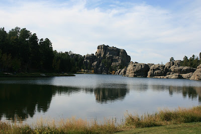 Sylvan Lake, Peter Norbeck Scenic Byway, Needles Road
The Byway led us to Custer State Park, where we found these friendly guys.
 Part of a herd of Wild Burros in Custer State Park
And the Fall colors are coming on.
 Someone has to be first!
 Trees outline the stream in the valley.
And we did return to Mt. Rushmore for the nightly Lighting Ceremony. The dark and lights made it hard to get good pictures, but here are two that will give you the idea.
 Through the State Flag Walk
 While the Armed Services Veterans from the crowd participate in the flag lowering ceremony, the Monument comes to life.
So now you know why I was so tired last night!
September 30, 2009
Travel (only) day. US16 from Hill City to I-90 at Rapid City. East on I-90 to Sioux Falls, SD. 386 miles.
High wind all day. 25-30 mph with gusts to 40 mph. From the southeast, so we were driving into it all day. Kind of like driving an old car with very loose steering -- exciting sometimes! Took our fuel economy down from 7.5 mpg to 5.4 mpg!
Did get to stop at the big Cabela's in Mitchell, SD. Better, we managed to walk out without buying anything!
Sorry, but no pictures. Didn't see anything worth the effort. Increased our understanding of why South Dakotans are so enamored of the Black Hills -- quite a difference!
Our plan for tomorrow is in a state of flux. Tune it tomorrow to see what we do!
Love to you all,
MMG and DDG
Monday, September 28, 2009
September 28, 2009 Jewel Cave National Monument, Wind cave NP, Mt. Rushmore
ADDITION TO September 26, 2009
Headline: Turkeys tie up traffic on I-90! And this time we're not talking about Prius drivers going 55 in the fast lane!
These turkeys were parading right across the Interstate as we approached from the West. The line stretched almost all the way across 4 lanes and the median. Both Westbound lanes had already stopped to let them pass and, of course we did, too. It took us a minute to get the camera out and going so we only got the last 13 or so........
 Turkey Trot on I-90
On to today!
A busy day! This morning we went on a tour of The Jewel Cave National Monument -- underground! The cave is the second longest known in the U.S. The longest is Mammoth Cave NP in Kentucky at 367 miles!
It is impossible to get pictures of what we saw that show the size and depth of the formations, so let's just enjoy the formations and the colors and let our imaginations run with what we see.
 Invasion of the Slime Monsters
 Ulcer?
 Outer Space Wormhole
 Your Guess ?
 See the fish ?
 Deep Space
 Jellyfish
 Gold!
Gold!
 Coral Reef
 Colors
 Stone Lily
 Creature from the Black Lagoon Reaching for You!
 More Colors
I think the most amazing thing to us is the fluidity of the formations and the colors that spring to life under the flash.
We had our daily picnic under a tree at the Monument then cruised on over t0 the Wind Cave National Park. We arrived too late for one tour and way too early for the next, so decided to drive around the Park while working our way back toward Mt. Rushmore.
The geography of Wind Cave NP is much like the Yellowstone valleys with flatlands and gentle hills. A big difference is that the pasturelands at Wind Cave are populated with thousands of Black-tailed Prairie Dogs and many Pronghorns -- and, yes, a few Bison.
We passed on pictures of the prairie Dogs and the Bison, but the Pronghorns were so close and the male had such a good rack that we couldn't resist!
 A First! All Faces!
 The Patriarch Herding His Harem
 Patriarch I
 Patriarch II
Then it was on the Mt. Rushmore.
 Guess Who, Guess Where.
 Through the Arch
We hope/plan to go back tomorrow to get some pictures with more favorable light. Also to return tomorrow evening to see the Lighting Ceremony. During the day we will take a couple of the scenic drives in Custer State Park.
More then!
Love to you all,
MMG and DDG
Headline: Turkeys tie up traffic on I-90! And this time we're not talking about Prius drivers going 55 in the fast lane!
These turkeys were parading right across the Interstate as we approached from the West. The line stretched almost all the way across 4 lanes and the median. Both Westbound lanes had already stopped to let them pass and, of course we did, too. It took us a minute to get the camera out and going so we only got the last 13 or so........
 Turkey Trot on I-90
On to today!
A busy day! This morning we went on a tour of The Jewel Cave National Monument -- underground! The cave is the second longest known in the U.S. The longest is Mammoth Cave NP in Kentucky at 367 miles!
It is impossible to get pictures of what we saw that show the size and depth of the formations, so let's just enjoy the formations and the colors and let our imaginations run with what we see.
 Invasion of the Slime Monsters
 Ulcer?
 Outer Space Wormhole
 Your Guess ?
 See the fish ?
 Deep Space
 Jellyfish
 Gold!
Gold! Coral Reef
 Colors
 Stone Lily
 Creature from the Black Lagoon Reaching for You!
 More Colors
I think the most amazing thing to us is the fluidity of the formations and the colors that spring to life under the flash.
We had our daily picnic under a tree at the Monument then cruised on over t0 the Wind Cave National Park. We arrived too late for one tour and way too early for the next, so decided to drive around the Park while working our way back toward Mt. Rushmore.
The geography of Wind Cave NP is much like the Yellowstone valleys with flatlands and gentle hills. A big difference is that the pasturelands at Wind Cave are populated with thousands of Black-tailed Prairie Dogs and many Pronghorns -- and, yes, a few Bison.
We passed on pictures of the prairie Dogs and the Bison, but the Pronghorns were so close and the male had such a good rack that we couldn't resist!
 A First! All Faces!
 The Patriarch Herding His Harem
 Patriarch I
 Patriarch II
Then it was on the Mt. Rushmore.
 Guess Who, Guess Where.
 Through the Arch
We hope/plan to go back tomorrow to get some pictures with more favorable light. Also to return tomorrow evening to see the Lighting Ceremony. During the day we will take a couple of the scenic drives in Custer State Park.
More then!
Love to you all,
MMG and DDG
Sunday, September 27, 2009
September 27, 2009 Trip to Rapid City
What a day! A cold front came through and the 60 degree temperature we woke up to was the high for the day. It only dropped into the low 50s, but the high winds made it pretty miserable.
We decided it would be a good day to do the laundry and go to Rapid City for some needed shopping. Our plan to go to visit a couple of the caves in the area today fell to the assumption that all the weekenders up here would decide to do the same thing to get out of the wind.
So we did laundry all morning (it had been a long time since we did laundry), then headed to the Big City for lunch and an afternoon of Target, WalMart, a Mall, and Cabela's.
The high point of the trip was the site of this herd of Big Horn Sheep that was helping with the lawn maintenance at a house just on the outskirts of Rapid City. So much for all the time we spend in the "wildlife viewing areas"!


And to wrap it up, a new record for the Pelicanlady World Famous Collection of Wildlife Butts -- the Whole Herd!

Cave visits, more scenic tours, and maybe Mt Rushmore tomorrow.
Love to you all.
MMG and DDG
Saturday, September 26, 2009
September 26, 2009 The Black Hills, Spearfish Canyon Scenic Byway, Devils Tower
Sightseeing day! Our main objective was to visit Devils Tower, but imagine our surprise when we found that the most direct route to Devils Tour, US385, would run right up the middle of the Black Hills, including a portion of the Black Hills National Forest, and that US385 would connect directly with Spearfish Canyon Scenic Byway!
What we had read about the Black Hills indicated that they included the highest peaks east of the Rockies in the U.S. May be, but we didn't see them. In fact, the scenery was more akin to a ride through the NC mountains, pretty, but not impressive, so we were a little down to start the day.
Things improved as we reached the end of US385 and turned toward the scenic byway. We were smack in the middle of Deadwood, SD (and every kid of my generation knows that Deadwood was a "Wild West" town where Wild Bill Hickok was killed) which (the entire town) is on the National Historic District list! It was interesting to see the town now.
Leaving Deadwood, we immediately found ourselves in Lead (pronounced "Leed") locally world famous as the site of the Homestake Mine, a gold mine, discovered in 1876 and continuously operated for over 125 years, producing over a $1 Billion in gold.
Not only did the Homestake have over 200 miles of underground tunnels, it also operated an open pit mine practically in right in town. The mine is 1200 feet deep and 1/2 mile wide!
 The Open Cut Mine, a gold pit mine, Lead, SD. Beautiful striations in the rock, no?
While we were checking out the offerings around the Lead visitor center, we were surrounded by flying insects resembling locusts, which I hadn't seen in any number since my days growing up on the family farm. They seem to come in three renditions, or perhaps stages of development. Here they are:
 Locust 1
 Locust 2
 Locusts 3 and 4
Then it was on to Spearfish Canyon. We had been told by a young couple we met in Glacier NP that this scenic drive was a "must do" if we were in the area, especially to see Bridal Veil Falls.
It was with visions of the famous Bridal Veil Fall in Yosemite NP that we set out. After seeing the shallow depth of the canyon, here:
 Spearfish Canyon
We weren't really expecting this:
 Artist's rendition of Bridal Veil Falls in Yosemite NP
But maybe this:
 Bridal Veil -- the real thing in Spring
Or even this:
 Bridal Veil -- the real thing in Fall
But for sure not this!
 Bridal Veil Falls, Spearfish Canyon, SD
We can't decide if that young couple, who live in SD, are really impressed with "their" Bridal Veil Falls -- it is pretty unique for this area -- or if they are still chuckling about how they sucked in the old folks.......
So, off to Devils Tower. Finally a place lives up to our expectations! As we approach:
 Devils Tower from several miles away.
 Facts about Devils Tower.
 Up close shot from the visitor center.
 Another angle.
 View from the trail around the base of the Tower.
And as we left the monument, we passed through the Black-tailed prairie Dog village these dudes posed for us.
 Dude 1
 Dude 2
And here's your flower for today!
 Spearfish Canyon Flower.
Tomorrow, maybe some cave exploring and maybe a trip to town!
Love to all,
MMG and DDG
Love to all,
MMG and DDG
Subscribe to:
Posts (Atom)
